
Choose Your November and December Trip by Temperature
Read our world temperature map, choose your preferred conditions and turn a climate shortlist into a packing plan.
You do not have to begin a vacation search with a country name. Sometimes the more useful starting point is how you want the trip to feel: cold enough for a winter setting, cool enough for long walks, mild enough for outdoor meals or warm enough for a beach-centered stay.
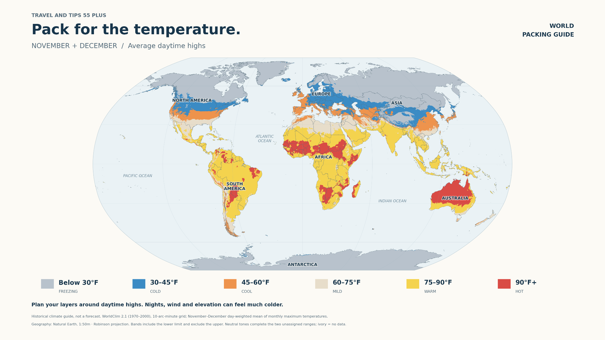
Our November–December world temperature map provides a visual starting point. Use it to identify regions that might suit your preferences, then investigate specific cities and dates. Choosing by temperature helps narrow the possibilities; it does not replace understanding the destination's activities, transport and seasonal conditions.
What the map actually shows
The map's caption identifies historical climate information from WorldClim 2.1, based on the period 1970–2000. It combines November and December monthly maximum-temperature averages, weighted by the number of days in each month. The colors describe average daytime highs for the combined period, not an average of every hour of the day.
This is not a live weather map or a forecast for your 2026 travel week. It is a historical regional guide. November and December may differ substantially in one place even when the combined map gives them a single color. Local elevation and small-scale conditions can also create variation that is not clear at this map's scale.
The broad color bands are helpful for comparing possibilities. Once you choose a place, use more specific, current information for packing and daily planning.
Read the six temperature bands
| Map band | Approximate Celsius equivalent | What to investigate |
|---|---|---|
| Below 30°F | Below −1°C | Cold-weather clothing, surfaces and outdoor exposure |
| 30–45°F | About −1–7°C | Morning and evening lows, wind and precipitation |
| 45–60°F | About 7–16°C | Flexible layers and protection for changing conditions |
| 60–75°F | About 16–24°C | Day-to-evening variation and the activities you plan |
| 75–90°F | About 24–32°C | Humidity, shade and comfortable outdoor timing |
| 90°F and above | About 32°C and above | Heat exposure, transport and cooler breaks |
The map's “Freezing” label names the lowest band; water's freezing point is 32°F, not 30°F. These bands are an organizing choice, not physical boundaries between travel experiences. Where a temperature sits close to a boundary, focus on the actual conditions rather than the label.
Cold-weather travel: make outdoor time intentional
If you want a winter atmosphere, consider what you hope to do outside and for how long. A brief walk between restaurants and a long outdoor excursion require different preparation. Snow, ice, rain and wind are separate questions; a cold temperature band does not guarantee snowfall.
Plan warming breaks and footwear suited to the expected surfaces. Consider transportation when choosing accommodation. Being near your priorities can make it easier to adjust the day when conditions change. A pleasant winter trip often depends on practical details that do not appear in the scenic photograph.
Cool-weather travel: layers are your friend
Cool conditions can suit sightseeing, but the day may still include colder starts, wind or rain. Use removable layers so you can adapt between outdoor walks, transport and heated buildings. The temperature itself does not describe the whole experience.
Think about which attractions will be outdoors and whether a sheltered alternative would still interest you. A museum, meal or performance can provide balance within the day. Avoid assuming that every destination in the same color band needs an identical wardrobe.
Mild-weather travel: examine evenings and water activities
A mild daytime high can look ideal for walking and outdoor dining. Check nighttime lows and whether a light layer will be useful after sunset. Also examine the conditions for your specific activities.
Comfortable air temperature does not establish comfortable swimming conditions. Water temperature, surf, wind and local guidance matter separately. A coastline suitable for a scenic walk on one day may not provide the beach activity you imagined. Decide whether swimming is essential to the vacation or simply a possible extra.
Warm and hot travel: look beyond the high temperature
A warm region can suit a beach or resort trip, but humidity, rainfall and wind influence comfort. A hot sightseeing day also differs from a hot day with shade and easy access to a room or pool.
Plan outdoor activities and breaks around the forecast and your own comfort. Investigate transportation, hotel temperature control and how much walking is involved. Avoid selecting a destination solely because its color looks warm. The kind of day you plan is part of the weather decision.
Why November and December need separate checks
A combined seasonal map can hide change between the months. If you travel across that period, compare November and December climate information for each stop. A late-November city stay followed by a mountain visit in December may require different preparation.
Research the actual city rather than using a country-wide description. Large countries and varied landscapes can include several climates. Elevation can produce a substantial difference between nearby locations. Our Arizona November idea is one example of why separate checks for each stop make sense.
Turn the map into a destination shortlist
First choose the conditions you prefer. Then identify regions of interest and select a few actual destinations. Compare those places using the activities you want, available travel time and transportation. Temperature should narrow the search, not make every other consideration disappear.
Next, check the historical seasonal pattern for each city, including highs, lows and rainfall. As departure approaches, examine the forecast for the dates you will be there. Leave enough flexibility in the itinerary to respond to conditions. A climate average explains a pattern; a forecast helps with the coming days.
Connect the choice to your travel wardrobe
Our clothing guides use 20–40°F and 40–60°F ranges, which do not match the map's six color bands exactly. Use the videos by their stated temperatures rather than assigning either one to a single map color.
Twenty to forty degrees Fahrenheit is approximately −7–4°C. Forty to sixty is approximately 4–16°C. Choose the clothing guidance that matches your expected conditions, then adapt it for lows, wind, precipitation and activities. We can add more temperature-based films as they become available.
Read our travel-wardrobe article for a detailed explanation of layers and the Sudoku packing grid. The map helps you decide where to go; specific city information and forecasts help you decide what to take.
What to pack for 20–40°F · approximately −7–4°C
Watch on YouTube ↗
A practical climate-planning checklist
Write down every city, your dates, typical highs and lows, likely precipitation, relevant elevation and the time you intend to spend outdoors. Add your preferred activities and a useful alternative for changeable weather. Then compare the wardrobe with that list.
If you know the temperature range you enjoy but have not chosen a destination, tell Andrea. We can use your climate preference alongside your travel interests to develop a shortlist that makes sense for the whole journey.
Sources and planning notes
Seasonal dates and product information checked October 12, 2026. Confirm specific hours, availability and booking terms before paying.
Let’s make it your trip.
Tell Andrea your dates, interests and preferred pace.